10_uav_rgb_m3_rgb_20230825
dataset of product airborne_rgb
Indexed by tai_odc_db_main_user
,
created
for
25th August 2023
Fields 🔗
cloud_cover
•
creation_time
2023-08-25 00:00:00
dataset_maturity
•
format
GeoTIFF
id
9a74013b-b05d-5f77-8da3-940b3b3ec644
instrument
•
label
10_uav_rgb_m3_rgb_20230825
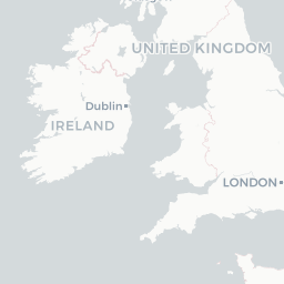
lat
52.854 to 52.862
lon
-6.922 to -6.913
platform
•
product_family
•
region_code
•
time
2023-08-25 00:00:00 to 2023-08-25 00:00:00