13_uav_msi_alt_rf_20220304
dataset of product tai_msi_rf
Indexed by tai_odc_db_main_user
,
created
for
4th March 2022
Fields 🔗
cloud_cover
•
creation_time
2022-03-04 00:00:00
dataset_maturity
•
format
GeoTIFF
id
74025976-758e-5020-a9b0-ea56ec51034f
instrument
•
label
13_uav_msi_alt_rf_20220304
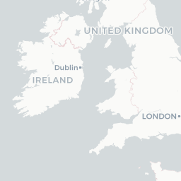
lat
52.566 to 52.574
lon
-6.619 to -6.607
platform
•
product_family
•
region_code
•
time
2022-03-04 00:00:00 to 2022-03-04 00:00:00